|
Ref: 116/ KNG/PD, Dt.05.06.2KX7 BLACK GRANITE DEPOSIT HOLDER SEEKING FOR FINANCIAL ENTREPRENEUR |
|
|
|
|
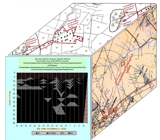
• Black Granite Deposit is a virgin area, situated about 6-8 KM from the Kanigiri town • Extent 21.77 Acres / 8.810 Hectares Documented Patta Land. • Adjacent to the Chinthalapalem actively working Quarries • Somanapalli (V), Kanigiri (M) Prakasam (Dt). • Scattered Black Granite boulders with sheet rock patches as exposures. • Geophysical Electrical ‘VES’ Exploration carried out up to a depth of 60M below ground level. • ‘VES’ Exploration results should be cross check limited locations with the aid of Core drilling. • ‘VES’ Exploration results reveal marketable dimensional 84,000 CMB per Hectare area. • ‘VES’ Exploration result reveals average 3.00 M Overburden to be removed before going to the mining. |
|
| TO WHOM SOEVER IT MAY CONCERN | |
|
This is to certify that this report is based on the soil analysis and theoretical calculations. The quantum of ‘Black Granite’ reserves are as expected marketable dimensional blocks production 84, 000 CBM per Hectare area. The GP ‘VES’ Exploration area/ proposed Quarry Lease area, over an extent of 21.77 Acres / 8.810 Hectares of Somanapalli Village, Kanigiri Mandal and Prakasam District. It is a documented patta land, is likely to be the order of 21, 28, 680 CBM of marketable Quantity based on GP ‘VES’ Exploration area. The quantities of 21, 000 CBM as Gange saw / Economical; 33, 600 CBM as Mini-Gange saw/ Marginal Economical and 29, 400 CBM as Cutter size / Sub-Economical marketable production expected in the GP ‘VES’ Exploration . Initially, before going to the Quarrying / Mining operation to be handled Over Burden, a quantity of 30, 000 CBM /per Hectare area. The calculated OB has to be removed in subject area, expected expenses is about 7.5 Lakhs, i.e. up to 3.0M below ground level depth from ground level. The Life of the calculated deposit per Hectare area is about 21.00 Years with 4000 CBM of annual production / annual marketable capacity. This Certificate is given based on the geological survey, GP ‘VES’ Exploration & More experience of the subject area in & around actively working Quarries and also based on the standard analysis parameters. |
|
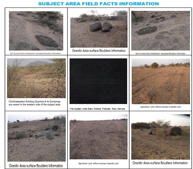
ENCLOUSERS: BRIEF REPORT – (1-5)/ 32pgs THE GP ‘VES’ EXPLORATION AREA DETALIS IN VILLAGE MAP ( 6-7)/ 32pgs GP ‘VES’ EXPLORATION AREA OF SATELLITE INFORMATION – ( 08)/ 32pgs THE GP ‘VES’ EXPLORATION LOATIONS GPS DATA – ( 09)/ 32pgs THE GP ‘VES’ EXPLORATION AREA FIELD FACTS – ( 10)/ 32pgs THE GP ‘VES’ EXPLORATION & ITS DEPTH WISE MAP – (11- 17)/ 32pgs THE GP ‘VES’ EXPLORATION AREA IN THE VILLAGE MAP – ( 18-24)/ 32pgs REGEONAL GEOLOGICAL MAP OF DIMENSIONAL STONE – ( 25)/ 32pgs BASIC DATA OF RESERVES & ITS ECONOMICS -( 26-28)/ 32pgs GP ‘VES’ EXPLORATION METHODOLOGY TEXT – ( 29-31)/ 32pgs THE GP ‘VES’ EXPLORATION & ITS DEPTH CONCERN TABLE – (32)/ 32pgs |
|